Sunday, September 29, 2013

Yosemite National Park, CA

The scale and beauty of Yosemite simply can not be captured on film. This is one of the first views you get of the valley driving north into the park from Fresno, CA on Wawona Rd. (click to enlarge) The valley (where most tourists stay) is in the right hand side of the panorama before you see the road. If you want to see a map so you know what locations I'm talking about throughout this post, click here.

Another picture heading in.

Deer are everywhere in the park and almost always draw a crowd of curious Europeans and photographers (such as myself). Picture and video taken in Yosemite village in the valley.


The first night in we had trouble finding a campsite in Yosemite valley so we headed up a mountain to hike at one of the many campsites in the park. We chose Hodgen Meadow because it seemed to be the closest to the valley. Here's a view of the moon rising from our campsite. While camping in Yosemite, you have to watch out for bears. Only use the bear save metal containers provided at each site, they can get into cars. They also like the smell of any bathroom items that may be scented like toothpaste so be sure and lock those up too!

The next morning dad and I went for a nice hike on the mist trail out of the valley. About 1,872 ft elevation gain and about 5.7 miles.

Here is a map of the hiking trail we followed.

This is a video of the topography of the whole valley which includes the trail we hiked.

At the beginning of the hike, the trail is deceptively nice and paved. You can see other openings in the mountains.


The first falls we reached was Vernal Fall 5044 ft above sea level.


Around this falls I saw a little squirrel who was remarkably comfortable around humans. He probably gets lots of food from the hikers.

The top of the fall.

This is the stream that produces the falls.

As we proceed we get our first glimpse of Nevada Fall.

Here is a view of the fall from the other side later on in our hike.

The stream that produces the water fall.

View from the top of our hike at 5,044 ft above sea level.

In the center of this picture is half dome. The summit is 8,836 ft above sea level.

Proof that I was there =P

We saw this little set up on the way out. I thought it was pretty cool since it just sits in the back of his truck.

Behind me is the valley on our way out on Tioga Rd at Olmsted Point. I'm wearing a jacket in this picture while in the other one I'm not wearing a shirt because it can get very windy out of the valley.

Same view without annoying people blocking it.

Here is a picture of Tenaya Lake. Its right along Tioga Rd. We were actually lucky to get to drive on this road as it had been closed due to fires that had been raging since May 21!


After driving about 30-40 mins you reach Tuolumne Meadows. We didn't stop for very long but there is a place to eat, camp and get gas.


Outside the park is Tioga Pass and it affords equally stunning views. Originally constructed in 1902-1910 and cost $63,00. It is considered by the American Society of Civil Engineers to be a landmark that displays the skill of the state engineers who designed it. It had a maximum grade of 7% although I'm not sure if that is true today or not since it was improved and re-built from 1965-1970.

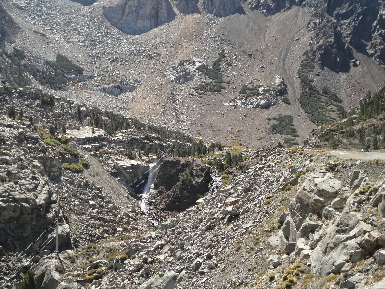
Panoramic shot, you can see the path the road follows on the left side if you look closely.


On the way to Ventura, CA Sept. 13th

On our way out of Encinitas, CA to Ventura, CA we passed through Santa Monica on route 1. If you've never driven on the coast of California-do it! I've had the privilege of doing it on two occasions and it has been breathtaking each time. In Santa Monica there are a lot of buildings built right on the hill side to view the ocean, like this apartment building where a unit could rent for around $6,000.

Further down the road we saw more mountains with buildings on them...

...it almost reminds you of iron man's house doesn't it? Which in fact is also in this area further up rt 1 at dune point (far left of photograph below), with the help of some digital editing. OK, so the awesome house doesn't actually exist but this is the spot the movie makers chose to use as the fictional location and cliff scenery. I read somewhere the chose it because you are not actually allowed to build on location and that it would be only fitting to have a super hero's house in a place no one is allowed to build.

Here is an abandoned hotel called Topanga Ranch Motel that I thought looked interesting. The famous character in Boy Meets World gets her name from the same place this hotel did--Topanga, CA just a little north west of Malibu.

After leaving Malibu, there is a long strip of coast line that is designated as wilderness and the impressive houses disappear. However, the impressive scenery does not. It is always awesome to see mountains dive straight into the water as you can see here.

Just outside Venture, CA you can see a lot of farm land that looks really pretty at sunset.

We got a hotel in Ventura in to spend the night before the boat ride out to the island Santa Cruz, part of the channel island chain. It was Dad's birthday while we were on our trip so I got him 20 energy drinks that he likes so much. I surprised him with them by putting them outside the bathroom door. We would need all the energy we could get to explore the large, beautiful island the next day...

Santa Cruz island, CA Sept. 14th

There are 3 ways out to the island: by air, by private boat or by chartering a boat. We went out on a boat with Island Packers, the only commercial boat allowed to land on the island by the National Park Service. Here is a picture of us leaving Ventura harbor on the ship's map.

An interesting sail boat we saw in harbor.

A picture from the starboard side while leaving the harbor in Ventura. Boat leaves around 8 am daily. Another leaves at 11ish.

The approximately 20 mile trip to and from the island affords many opportunities to see wild life such as whales, sea lions, ocean birds, and dolphins. On the way out, we got to see sea lions hauling-out on a buoy.

While we did not see any whales, there were plenty of dolphins!


This is the main land as we are on the boat. It may be visible from the island on a good day.

There were also several oil platforms off shore that we could see. The island in the background I think is Santa Cruz.

A closer panorama of Santa Cruz. It is the largest island in the Channel Island chain. According to Island Packers "The eastern 24% of the island is National Park Service (NPS) property. The western 76% is owned and managed by The Nature Conservancy (TNC)." Because the boat was bouncing up and down so much, the panorama function on my camera didn't work. I had to stitch these two images together on my computer using a free program called hugin so you could see the whole island.


Just to give you some perspective, we are heading to the circled area above and all the pictures you see below on the island or in the water was taken within the little white circle you see on the map below. Keep in mind that this map only shows the NPS's property, 76% of the island you don't even see. Also keep in mind that this is just one of the five islands in the channel islands national park.

At Scorpion Anchorage (red dot on the map above), the ship let us off. It just drives up to the dock and keeps its engines running forward to keep the bow up against the dock while people get off.


Scorpion Anchorage is a busy spot with kayakers, snorkelers and people just sitting on the beach (although most of it is rock and not sand). The small boats you can see in the picture are private boats. I met some locals who take their boat here all the time to kayak (although kayaking out would be crazy but some do it as I'll show you below). There are also commercial kayak tours available.

The trip up to the visitor center displays the islands history as a ranch. In the late 1800s it was profitable to build a ranch out here because there were no natural predators, no need to build fences and no rustlers (as there were in tombstone). You can still see the old farming implements such as plows, mowers, and cement mixers.

As the island didn't become a national park until 1980, there is more modern equipment there as well. This is the Oliver 70 built in 1946 and was brought to the island in 1954.

Humans have been on the islands for a long time. 13,000 year old bone fragments of a human leg bone on Santa Rosa is the oldest known human presence in North America. The Chumash Indians eventually settled on the island. Today they make the trek from the mainland to the island in their tomol (canoe) to preserve their heritage.

Camping is also allowed on the island and must be an awesome experience. I'm definitely going to go back and camp someday. Here is a picture of the upper campsite about 3/4 miles inland.

Here is the lower campground about a quarter mile inland.

Everything on the island is solar powered. Here is the pump house which brings up water from the well into a water tower for use by the campsites.

The visitor center is solar powered as well. However they are all dusty because they are not being used right now because the batteries connected to them are dead. They cannot change the batteries because they do not want to disturb a bat colony roosting by the battery bank.

Although most of the spots we stopped were very impressive, Santa Cruz was my favorite (although there are close seconds). I have heard the islands described as the "Galapagos of California" due to its low visitation and unique endemic species. The island chain is home to 145 species of plants and animals found nowhere else on earth. Below is a picture of an island fox which is not found anywhere else in the world. Everything was going great for them accept when the ranching started, it brought with it wild pigs. This in turn brought non-native golden eagles to prey on the feral pigs and then also the island foxes. The foxes were particularly vulnerable because they have no natural predators and were not used to hiding. From 1999-2006 the eagles were trapped and moved to other remote places. The pigs were also removed by hunting and the island fox population returned. Since they have no natural predators, they are not as skiddish as animals on the mainland.


Here is where the volunteers and rangers stay over night complete with restrooms and a community kitchen.

We got to go on a 2 mile hike with one of the rangers on cavern point loop.

Here is a deposit of diatomaceous earth we encountered on the way up which has many applications including pool filters.

The view at Cavern Point. Absolutely breath taking. Apparently it was also a garbage dump for the Chumash. I guessed that it was up at this beautiful vantage point to motivate the people to take out the trash but the ranger said experts believe it had more to do with isolating the smell.


As you walk back down the trail you see Scorpion Harbor again. In the foggy distance is Anacapa Island.

Picture of a sailboat for my grandpa. He loves sailboats.

After the hike, we went snorkeling in the kelp forests. Here is what it looks like from above.

Here is what I believe to be a dead spiny spider crab (Maja squinado) or it could just be the exoskeleton or exuvia.

Here are some kayakers enjoying the water. They had rigid ones but we brought our own blow up one.

Some hikers on the cliff above.

The Channel Islands has a lot of kelp which needs rich nutrients to survive. In the post about San Elijo State Beach, I mentioned how the air sacs keep the photosynthesizing parts close to the sun. Here you can see it being lifted up by the air.

Perhaps one of the most exciting things we saw were bat rays.


Looking for food.

Fish and the kelp forest.

After a long interesting day we were sad to return to the harbor around 6 pm.